Hurricane Tammy: Latest track and spaghetti models

Editor's Note: Get the latest forecast updates by clicking on the video above.
Check here for the latest updates for Hurricane Tammy.
APP USERS: Tap here for the full experience
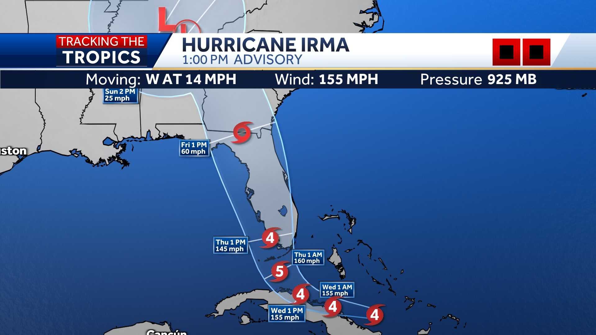
LATEST CONE
LATEST MODELS
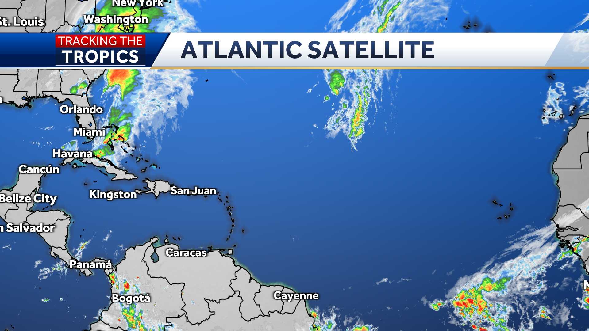
ATLANTIC SATELLITE
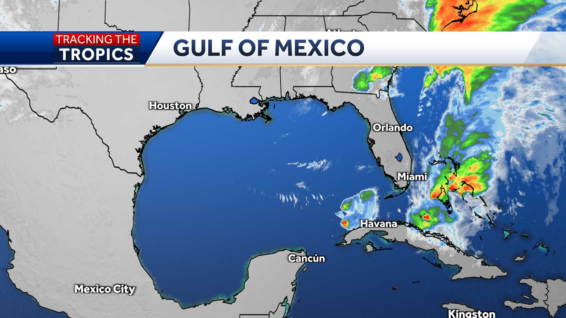
GULF SATELLITE
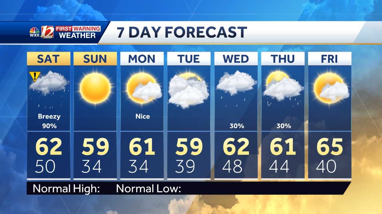
7-DAY FORECAST
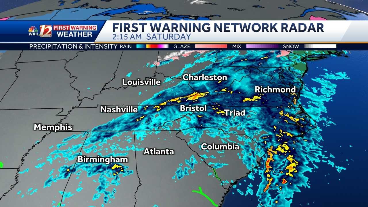
LIVE RADAR
More from WXII
- CLICK HERE for the latest forecast and videocast
- North Carolina DOT Hurricane Evacuation Routes
- Supplies to help you survive a hurricane
- Hurricane Vocab: 12 Terms You Need To Know
- Hurricane Warning Checklist
- Hurricane Watch Checklist
- Talking with Children about Hurricanes
- Tips: Pets and Hurricanes
- Hurricane Myths Dispelled
From watch to warning, know your hurricane terms
It is important to know the difference between the severity of storms during Hurricane Season.
Below is an explanation so you properly plan for an emergency in the event of a natural disaster.
Tropical storms and hurricanes each have two descriptors, a watch and a warning. A Watch means tropical storm or hurricane conditions are possible in the “watch area.” A watch is issued up to 48 hours in advance of the onset of tropical storm-force winds.
A Warning is issued when a tropical storm or hurricane conditions are expected in the “warning area.” A Warning is issued up to 36 hours in advance of the onset of tropical storm-force winds.
Hurricane preparedness activities become difficult once winds reach tropical storm-force. Watches and Warnings are issued in advance of the onset of tropical storm force winds (39-73 mph)
How we rate hurricanes
The Saffir-Simpson Hurricane Wind Scale is a 1 to 5 rating based on a hurricane's sustained winds, according to the National Oceanic and Atmospheric Administration. Category 3 and above are considered major hurricanes, but precautions should still be taken for Category 1 and 2 storms. NOAA and Weather.gov put together the following information that explains how each storm category is defined and what type of damage is expected.
Tropical Depression
A tropical depression is a tropical cyclone that has maximum sustained surface winds (one-minute average) of 38 mph or less.
Tropical Storm
A tropical storm is a tropical cyclone that has maximum sustained surface winds ranging from 39-73 mph.
Category 1: Sustained winds of 74-95 mph
Very dangerous winds will produce some damage: Well-constructed frame homes could have damage to roof, shingles, vinyl siding and gutters. Large branches of trees will snap and shallowly rooted trees may be toppled. Extensive damage to power lines and poles likely will result in power outages that could last a few to several days.
Category 2: 96-110 mph
Extremely dangerous winds will cause extensive damage: Well-constructed frame homes could sustain major roof and siding damage. Many shallowly rooted trees will be snapped or uprooted and block numerous roads. Near-total power loss is expected with outages that could last from several days to weeks.
Category 3: 111-129 mph (Major Hurricane)
Devastating damage will occur: Well-built framed homes may incur major damage or removal of roof decking and gable ends. Many trees will be snapped or uprooted, blocking numerous roads. Electricity and water will be unavailable for several days to weeks after the storm passes.
Category 4: 130-156 mph (Major Hurricane)
Catastrophic damage will occur: Well-built framed homes can sustain severe damage with loss of most of the roof structure and/or some exterior walls. Most trees will be snapped or uprooted and power poles downed. Fallen trees and power poles will isolate residential areas. Power outages will last weeks to possibly months. Most of the area will be uninhabitable for weeks or months.
Category 5: 157 mph or higher (Major Hurricane)
Catastrophic damage will occur: A high percentage of framed homes will be destroyed, with total roof failure and wall collapse. Fallen trees and power poles will isolate residential areas. Power outages will last for weeks to possibly months. Most of the area will be uninhabitable for weeks or months.